September 12, 2026
Maine Open Lighthouse Day Information…
This popular annual event, which is sponsored by the American Lighthouse Foundation, the United States Coast Guard, and the Maine Office of Tourism, attracts between 15,000 to 18,000 visitors each year and offers the general public the rare opportunity to climb and learn about more than a dozen historic Maine lights.
List of participating sites:
The following is a list of the 2025 participating lighthouses — please check back in early June for the 2026 event updates and details.
All lighthouses are open 9:00 am to 3:00 pm unless otherwise noted. Lighthouses may have a height requirement to climb, please visit their website for more information.
Burnt Coat Harbor Lighthouse

Location: Swan’s Island (offshore)
**NOTE SPECIAL TIME: 10am to 3pm
Historic Buildings Open: Light tower and keeper’s house
How to Get There: Maine State Ferry from Bass Harbor to Swan’s Island. Please see ferry’s website for schedule and fees at: www.maine.gov/mdot/ferry/swansisland/ or call (207) 244-3254.
Coordinates: 44°08′ 03″ N 68°26′ 50″ W
The lighthouse is an active Coast Guard aid to navigation. The light station is owned by the Town of Swan’s Island, and the historic buildings are cared for by the nonprofit Friends of Swan’s Island Lighthouse. For more info, visit: www.burntcoatharborlight.com
Burnt Island Lighthouse

Location: Boothbay Harbor (offshore)
**NOTE SPECIAL TIME: 10am to 2:15pm
Historic Buildings Open: Light tower and keeper’s house (Living history museum inside)
How to Get There: Offshore…Water taxi (tickets required) available via Balmy Day Cruises located at Pier 8 in Boothbay Harbor.
The lighthouse is an active Coast Guard aid to navigation. The light station’s historic buildings are owned and managed by the Maine Department of Marine Resources. For more info, visit: www.maine.gov/dmr/programs/education-division/burnt-island-lighthouse
Coordinates: 43°49′ 31″ N 69°38′ 27″ W
Dyce Head Lighthouse

Location: Castine (land-based)
**NOTE SPECIAL TIME: 10am to 2pm
Historic Buildings Open: Light tower only
How to Get There: Land based
Coordinates: 44°22′ 57″ N 68°49′ 07″ W
The lighthouse is an active aid to navigation. The light station’s historic buildings are owned and managed by the Town of Castine. The keeper’s house is a private residence (please respect the tenant’s privacy).
Fort Point Lighthouse

Location: Stockton Springs (land-based)
Historic Buildings Open: Light tower (contains a Fresnel lens)
How to Get There: Land based
Coordinates: 44°28′ 02″ N 68°48′ 42″ W
The lighthouse is an active Coast Guard aid to navigation and contains a beautiful fourth order Fresnel lens. The light station’s historic buildings are owned by the State of Maine and managed by the Fort Point State Historic Site. The keeper’s house is the residence of the Park Ranger and his family (please respect their privacy).
Goat Island Lighthouse

Location: Cape Porpoise (offshore)
Historic Buildings Open: Light tower and grounds
**NOTE SPECIAL TIME: 12pm to 3pm
How to Get There: Offshore…visitors must find their own boat transportation to the island. If you enjoy kayaking, you are welcome to come ashore and tour the lighthouse.
Coordinates: 43°21′ 30″ N 70°25′ 30″ W
The lighthouse is an active Coast Guard aid to navigation. The light station’s historic buildings are owned and managed by the Kennebunkport Conservation Trust. For more info, visit: www.kporttrust.org
Grindle Point Lighthouse

Location: Islesboro (offshore)
Historic Buildings Open: Tower, Keeper’s House Sailor’s Museum, Oil House and Gift Shop
**NOTE SPECIAL TIME: 9:30am to 4:30pm
How to Get There: Maine State Ferry from Lincolnville to the island of Islesboro. Please see ferry’s website for schedule and fees at: www.maine.gov/mdot/ferry/islesboro/ or call (207) 633-2284.
Coordinates: 44°16′ 56″ N 68°56′ 34″ W
The lighthouse is an active Coast Guard aid to navigation. The light station’s historic buildings are owned and managed by the Town of Islesboro. For more info, visit: grindlelight.com
Little River Lighthouse
Location: Cutler (Offshore/ island)
Historic Buildings Open: Tower
How to Get There: Offshore…Boat transportation will be available departing from Cutler’s Town Landing. FMI visit: https://www.littleriverlight.org/events/
Coordinates: 44° 39′ 03″ N 67° 11′ 32″ W
The lighthouse is an active Coast Guard aid to navigation. The island and light station’s historic buildings are owned and managed by the American Lighthouse Foundation.
Marshall Point Lighthouse

Location: Port Clyde (land-based)
**NOTE SPECIAL TIME: 10am to 4pm
Historic Buildings Open: Tower and Keeper’s house (Museum & gift shop inside)
How to Get There: Land based
Coordinates: 43°55′ 03″ N 69°15′ 41″ W
The lighthouse is an active Coast Guard aid to navigation. The light station’s historic buildings are owned and managed by the St. George Historical Society. For more info, visit: www.marshallpoint.org
Monhegan Island Lighthouse

Location: Monhegan Island (offshore)
Historic Buildings Open: Light tower and keeper’s house (Museum inside)
**NOTE SPECIAL TIME: 11:30am to 3:30pm
How to Get There: Offshore…Boats from Port Clyde, New Harbor and Boothbay Harbor. Please see websites for the following companies for schedules and fees:
Monhegan Boat Line: monheganboat.com
T:(207) 372-8848
Hardy Boat Cruises: hardyboat.com/
T:(207) 677-2026
Balmy Days Cruises: www.balmydayscruises.com
T:(207) 633-2284
Coordinates: 43°45′ 54″ N 69°18′ 54″ W
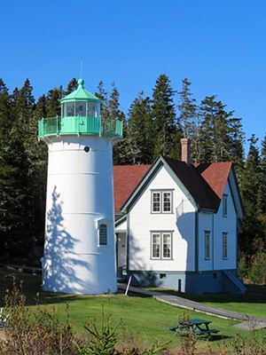
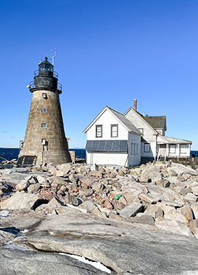
Moose Peak Lighthouse

Location: Mistake Island (offshore)
Historic Buildings Open: Light tower
How to Get There: The private owners will be making two boat trips (7 passengers per trip) from Jonesport to Mistake Island. Please contact the owners of Moose Peak Light at the following email address for more information: moosepeaklighthouse@gmail.com
For those visiting the island on their own the tower will be open 9am to 3pm.
Coordinates: 44°28′ 27.7″ N 67°31′ 55.3″ W
The lighthouse is an active Coast Guard aid to navigation. The light station structures are privately owned.
Owls Head Lighthouse

Location: Owls Head (land-based)
Historic Buildings Open: Light Tower (9am-4pm) & Historic Keeper’s House (Interpretive center & gift shop inside)
Special Activities: Book Signing – Author Angeli Perrow will signing copies of her popular children’s book, Lighthouse Dog to the Rescue, inside the keeper’s house from 1pm to 4pm.
How to Get There: Land based
Coordinates: 44°05′ 33″ N 69°02′ 39″ W
The lighthouse is an active Coast Guard aid to navigation and contains a beautiful fourth order Fresnel lens. The light station’s historic buildings are cared for by the American Lighthouse Foundation and serves as the headquarters for the nonprofit organization. For more info, visit: www.lighthousefoundation.org/lighthouses/owls-head-light/
Pemaquid Point Lighthouse

Location: Bristol (land-based)
Historic Buildings Open:
Light tower (Cared for by the Friends of Pemaquid Point Lighthouse) **Tower Tours: 9am to 5pm
Keeper’s House (Museum inside, which is operated by the Town of Bristol)
How to Get There: Land based
Coordinates: 43°50′ 12″ N 69°30′ 21″ W
The lighthouse is an active Coast Guard aid to navigation and contains a beautiful fourth order Fresnel lens. The light tower is cared for by the Friends of Pemaquid Point Lighthouse, a chapter of the American Lighthouse Foundation. If you want to make a donation to the lighthouse for its ongoing care and preservation, it must be done inside the tower itself, which is staffed by Friends of Pemaquid Point Lighthouse volunteers. For more info, visit: www.pemaquidpointlight.org/visit/
Portland Breakwater Lighthouse (Bug Light)

Location: South Portland (land-based)
Historic Buildings Open: Light tower only.
How to Get There: Land based
Coordinates: 43°39′ 20″ N 70°14′ 06″ W
The lighthouse is a private aid to navigation and is owned by the City of South Portland.
Portland Head Lighthouse
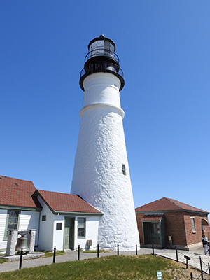
Location: Cape Elizabeth (land-based)
**SPECIAL NOTE: Approximately 300 tickets will be made available for visitors on a first-come-first serve basis the day of the event, which are necessary for climbing the tower. You must be at least 48 inches tall and able to handle 85+ steps unassisted to climb the tower.
Historic Buildings Open: Light tower and keeper’s house (Museum inside & adjacent gift shop)
How to Get There: Land based
Coordinates: 43°37′ 24″ N 70°12′ 30″ W
The lighthouse is an active Coast Guard aid to navigation. The light station’s historic buildings are owned and managed by the Town of Cape Elizabeth. For more info on the Museum at Portland Head Light, visit: www.portlandheadlight.com
Rockland Breakwater Lighthouse

Location: Rockland (land-based via a 7/8-mile breakwater)
**NOTE SPECIAL TIME: 10am to 1pm
Historic Buildings Open: Light tower and keeper’s house
How to Get There: A 7/8-mile walk out the breakwater.
Coordinates: 44°06′ 15″ N 69°04′ 39″ W
The lighthouse is an active Coast Guard aid to navigation. The light station’s historic buildings are owned by the City of Rockland.
Spring Point Lighthouse

Location: South Portland (land-based via a breakwater)
Historic Buildings Open: Light tower
**NOTE: Numbered tickets will be available near the gift shop from 10:00am to 1:30pm. You must be 51” or 4’3” to tour the lighthouse.
How to Get There: Land based via a breakwater at the Southern Maine Community College
Coordinates: 43°39′ 07″ N 70°13′ 26″ W
The lighthouse is an active Coast Guard aid to navigation and is owned and managed by the Spring Point Ledge Light Trust. For more info, visit: springpointledgelight.org/
Squirrel Point Light

Location: Arrowsic
**NOTE SPECIAL TIME: 10am to 3pm
Historic Buildings Open: Keeper’s house only (Lighthouse tower is closed)
Coordinates: 43° 49′ 00″ N 68° 48′ 06″ W
How to Get There: Land based. Squirrel Point Light lies at the end of 2/3 mile trail in Arrowsic, Maine, approximately 10 miles from the City of Bath. Park at the end of Bald Head Road. The footpath through protected forests and wetlands is uneven and rough in places. No restrooms or drinking water available. The keeper’s house is scheduled to be open to visitors. (Lighthouse tower is closed)
For detailed directions visit www.squirrelpoint.org/visit.html.
Other Lighthouse Attractions:
Maine Lighthouse Museum

Location: One Park Drive, Rockland
The Museum has the largest collection of Fresnel lenses on display in the nation. Other exhibits pay tribute to our lighthouse history (both the U.S. Lighthouse Service and U.S. Coast Guard eras), as well as the United States Life-Saving Service. The Museum is a must-see while visiting Maine’s lighthouses.
FMI: Visit www.mainelighthousemuseum.org or call (207) 594-3301.
Maine Maritime Museum

Location: 243 Washington Street, Bath
The Museum’s exhibit “Into the Lantern: A Lighthouse Experience”, featuring a full-scale replication of the Cape Elizabeth Two Lights lighthouse tower lantern room, allows visitors to see the original second-order Fresnel lens from the east tower at Two Lights and experience the environment of the lantern room through time-lapsed video projections featuring a panorama of the Gulf of Maine that changes with the weather and seasons. This immersive exhibit is the first of its kind anywhere.
FMI and Admission Fees Visit: www.mainemaritimemuseum.org or call (207) 443-1316.
Bar Harbor Whale Watch – Bold Coast 18 Lighthouse Cruise
Event Location: 1 West Street, Bar Harbor
FMI: See the light stations of the Downeast and the Bold Coast of Maine to Grand Manan Island in the Bay of Fundy! This narrated trip offers ample time at each light for excellent photography. For more info, visit: www.barharborwhales.com/boldcoastcanadagrandslamlighthousecruise/ or 1-888-WHALES-4
Maine Open Lighthouse Day – Participating Sites Map
View Maine Open Lighthouse Day in a larger map